AS the digital ag evolution continues to disrupt the way we farm crops, gathering data is becoming more critical.
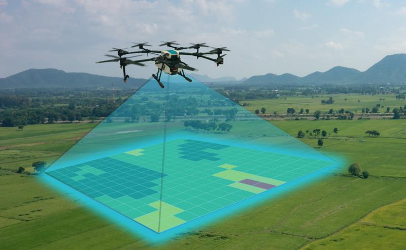
Soil probes in the ground, yield monitors on machines and drones in the air are collecting information that can be used to pinpoint areas of low crop health or differing soil conditions. These areas can then be efficiently treated.
The end game is to boost productivity, but the investment in the right technology can be high and learning to use it time-consuming and confusing, so for some farmers it’s difficult to see the return on investment.
New technology paving the way for better plant health
Agriculture drones in particular have a hard barrow to push when convincing farmers that they can provide meaningful productivity gains. Beyond the face value benefit of being an eye in the sky to check over paddocks and fence lines, drones and drone services have been sold as a means to scan crops to create Normalised Difference Vegetation Index (NDVI) maps.
 Agritech is a growing industry which is based upon improving productivity. Source: iStock.
NDVI is based on the decades-old discovery that healthy plants absorb and reflect light at specific frequencies differently than unhealthy ones. With this, scientists developed an algorithm which, used in conjunction with satellite imagery, can provide growers with a picture of plant health expressed in simple colour charts.
While NDVI maps can be useful in identifying areas of stress and weed proliferation to help make better decisions for chemical use, they have their limitations. Precision Agriculture founder Andrew Whitlock recently explored the use of special data for the
Grains Research and Development Corporation.
“NDVI provides an assessment of canopy density, biomass and plant vigour,” he says. “NDVI will not define the underlying factor promoting or limiting plant growth, it simply indicates where to investigate (visual, plant testing, soil testing, etcetera) and helps define boundaries around such factors.
“Multiple layers of data and/or integration of existing paddock knowledge will be required to validate NDVI imagery. For example, nutrient imbalance would require additional soil testing to understand what is deficient, while suspected diseased crop would need to be tested to identify the pathogen and to prescribe a treatment.”
Cost benefits of satellite imagery with NDVI maps
So, NDVI maps are not a silver bullet, but are still useful. They can also be created much more cost-effectively using imagery from satellites, rather than from drones. “We’ve used satellites because it’s cheaper and more efficient,” Andrew says of his own broadacre farming operation.
“You can get satellite imagery for free or very low cost, so if you don’t have free imagery, you’re not in the game.”
This creates a challenge for the pioneers in drone mapping who started to appear five years ago offering detailed high-resolution farm imagery. The service involves a fixed-wing drone flying over a property on a set grid, collecting snapshots with expensive near-
infrared and multi-spectral cameras.
After this process, the imagery has to be stitched together with a computer to create a meaningful picture which can take many hours, so the costs add up. Still, Andrew believes there is a use for this level of detail. “Satellite imagery is fine for the average farmer, but if you really want the resolution down to the centimetre, then drones can achieve that,” he says.
RELATED ARTICLES:
Drones and farms: know your rights
When will agriculture's robotic revolution arrive?
Virtual fences to improve labour efficiency for farmers
How to decide what drone to use on-farm
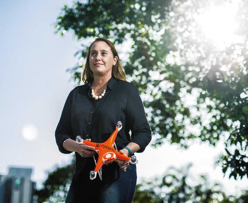 Drones business owner Meg Kummerow believes that ag knowledge is essential when matching farmers with the technology. Source: Newspix.
Meg Kummerow, of agriculture drones systems business
Fly the Farm in Queensland, agrees. “You get a broad image with a satellite and it may show a trouble spot, but if you want detail, putting a drone over that spot can provide a lot more information,” she says. “And that’s where a drone service provider can really be useful.”
Meg grew up on a beef cattle property and is currently an independent director and executive officer of the Grains Research Foundation and a committee member of the Australian Sunflower Association. She also represented agricultural use of drones to a federal government Senate committee looking into commercial and recreational drone use. She started her business in 2017 after being frustrated by the lack of solid information about available drone systems for individual farming operations.
“Farmers needed somewhere to go to find out what was going to meet their needs without being sold the most expensive thing out there,” Meg says.
“The choice of drone or drone service depends on the level of interest and what a farmer wants to achieve. Prescription mapping is only relevant to those who have the equipment to properly use it, but drones offer a lot more than that.”
Meg says software such as
DroneDeploy has made crop monitoring much easier for farmers and advisers by providing cheap, basic imagery including ‘false NDVI’ – which is generated by using the everyday camera that comes with the drone, as opposed to expensive sensors.
“False NDVI is just a fancy term for adding algorithms to a band of light in any regular drone camera to gain insights into what is happening in their field,” Meg explains.
Monitoring crop health using false NDVI was used successfully to control plant disease on the Darling Downs in 2016, Meg says. “It was a particularly wet winter and there were a lot of chickpeas in and when you get those things together, that means fungal disease. One farmer put up a drone to track the spread of the disease using false NDVI and through that was able to make the decision to put a plane over the crop to treat it with a fungicide. After that, he used the drone to monitor the crop’s health.”
On farm drones: cost versus productivity
Beyond that, Meg says she sees many other uses for cheap and simple drones. “Improving safety outcomes is also a really important use for drones. Need to check something at the top of your silo complex? Send up a drone. Need to check what’s happening during a flood event? Send out the drone – within visual line of sight of course, and not when it’s raining.”
She says her cattle farming father takes a drone with him wherever he goes. “He’s 81 and runs a 10,000-acre cattle property by himself and a lot of his country is pretty rough,” she says. “He can get up on a ridge, put a drone out and see the cattle are over in a corner somewhere, instead of having to ride the whole paddock again.”
Fitting a drone with a thermal camera is also useful for finding strays in thick bush and some dairy farmers are even driving small herds with the drone itself. A drone fitted with a bird scarer can be used in orchards. These applications are relatively cheap and good for saving time and energy. Much larger drones capable of carrying liquid tanks to spot-spray herbicides, fungicides and fertilisers are also emerging. But it’s the camera mounted on the drone that is even capable of measuring plant size that’s proving the most valuable tool. Andrew Whitlock says there many uses for that level of detailed imaging.
“It could be in horticulture where the size of each plant or fruit can be measured individually so a robot or pickers would know where to pick,” he says.
Getting back to broadacre productivity gains, he says farmers can get confused by the influx of new technology. “There is an absolute hurry for people to get market share in soil mapping and other drone-collected data, but we need to make sure we don’t drop the ball on traditional methods,” he says.
“I think we have a lot of proven science in soil and we shouldn’t throw all that out. Instead the approach to any technology should focus on what the issues are on the farm using this available information and work backwards. How existing proven technology can be intensified. That’s where drones can become very useful.”
RELATED ARTICLES:
Could Wagga Wagga become the next Silicon Valley?
Can digital agriculture bring farmers big rewards?
Drone buyers guide
A chat with your local agronomist might help with the decision around buying a drone to suit your needs, but here’s a rough guide to get you started.
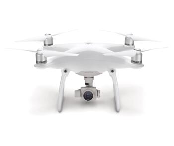 DJI Phantom 4 Pro
Thought to be the most popular drone on the market, this relatively cheap drone has a 30-minute flight time and has a simple gimbal-mounted camera for photos and streaming video. There are smaller and cheaper drones, but the Phantom 4 has the camera quality, range and battery life to make it more suitable to ag.
$2,399.
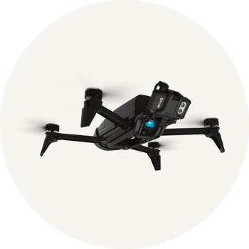 Parrot Bebop 2 Pro Thermal
Thermal inspection is useful for livestock farmers to find animals lost in thick bush and can also be good for inspecting hot farm machinery such as combine harvesters, or solar panels, or farm structures for faults. The camera can also be switched to visual mode to make it a useful eye in the sky.
$2,199.
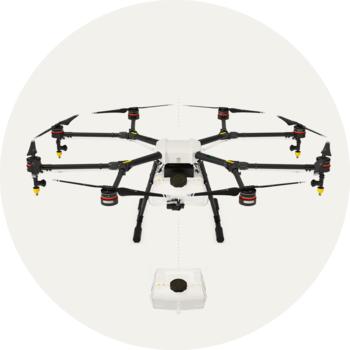 DJI Agras MG-1S
Now we’re getting into precision sprayer technology. This drone carries a 10-litre tank and flies for 10 minutes with a full load, but can cover a large area in that time. Good for spot-spraying trouble areas with minimum crop disturbance.
$18,999.
.jpg) SenseFly eBee
SenseFly eBee
A fast fixed-wing drone designed to cover large areas and carry for NDVI mapping. The cheapest version carries a multi-spectral camera for simple mapping. The most expensive includes a positioning package to give it excellent accuracy without the need for ground control points.
$11,500-$50,000 (depending on specification).